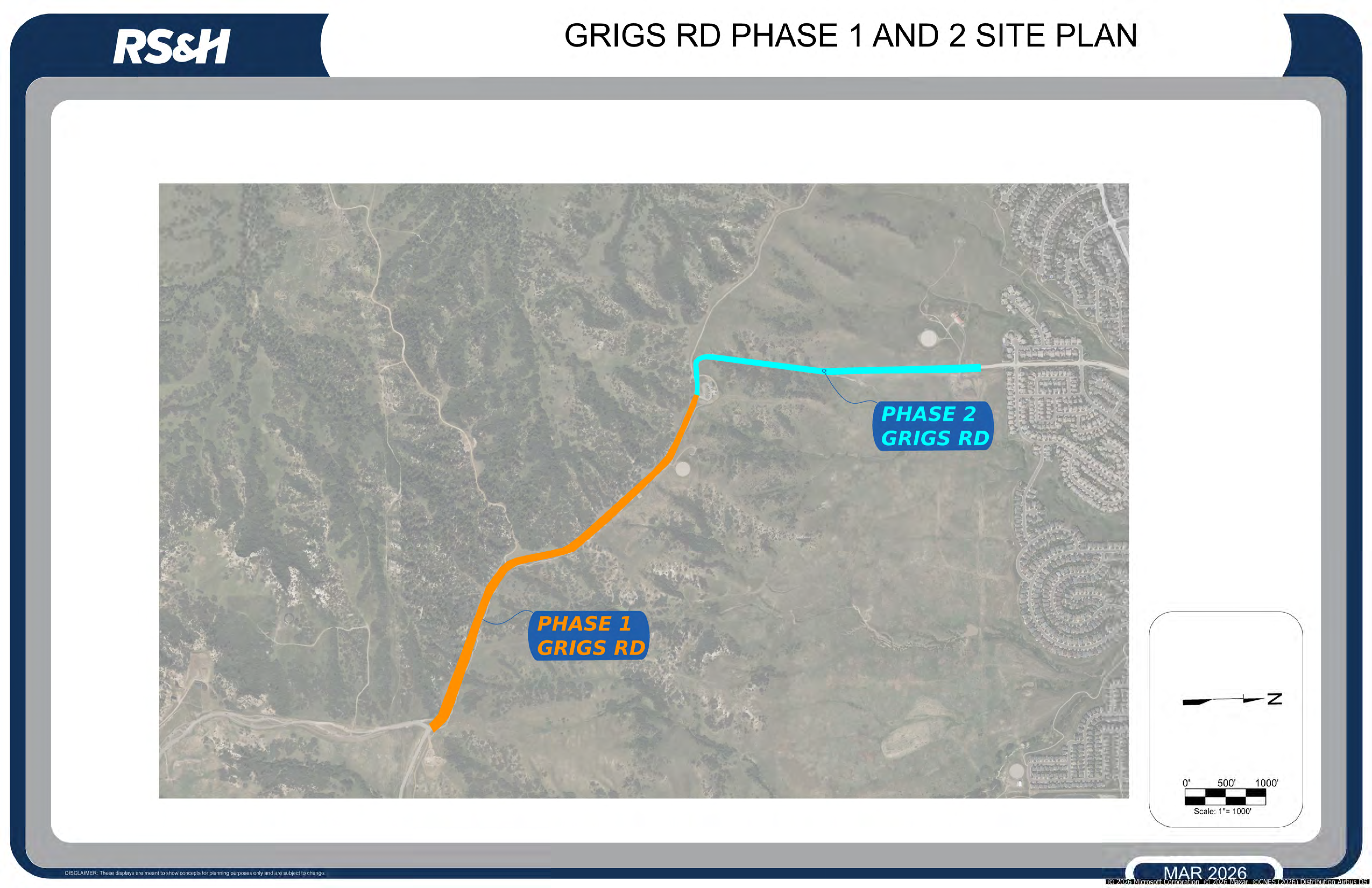
Project Overview
Grigs Road, a key link between Highlands Ranch and Daniels Park/Castle Pines, is undergoing improvements in two phases. Douglas County engineering staff is managing the project and is collaborating with staff from the Highlands Ranch Metro District and the Highlands Ranch Community Association. The design engineer is RS&H.
Phase One
Phase one added asphalt pavement and drainage upgrades along the first 0.8 miles from Daniels Park Road toward the East-West Connector trailhead.
Phase Two
Phase two will extend the work by connecting phase one to the existing concrete pavement to the north, completing the remaining mile of the 1.8-mile corridor.
Scope
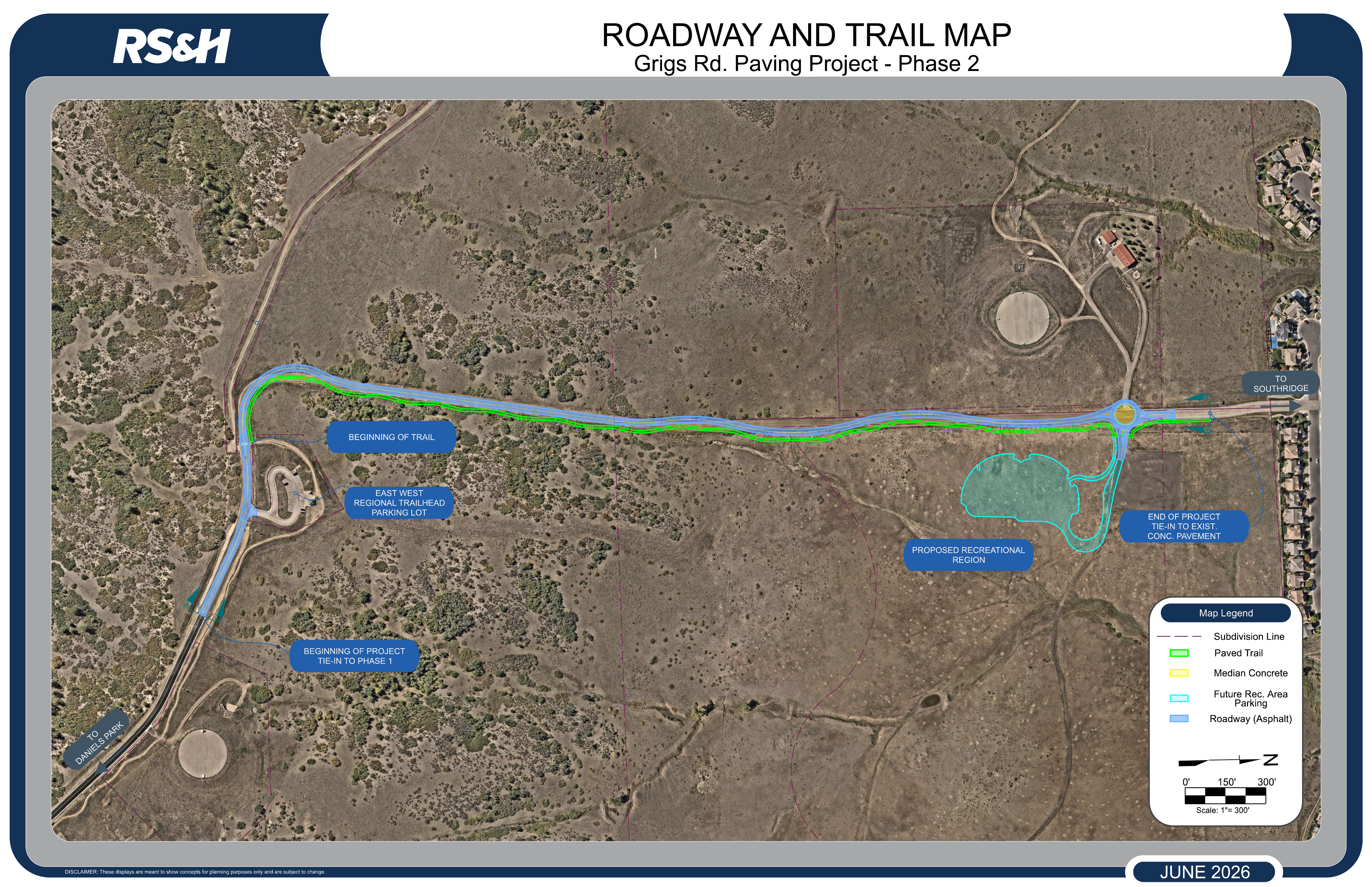
- The Grigs Road Phase 2 project will include construction of a 24-foot-wide asphalt roadway with curb and gutter, drainage improvements, and safety enhancements to address curves and steep slopes near the trailhead.
- The benefits of paving the gravel road are to improve driver safety, including stopping distance, to reduce required maintenance, and to reduce airborne particulates.
- Additional improvements include a roundabout at the future entrance to Wildcat Regional Park and a shared-use trail for pedestrians and bicyclists to improve connectivity and safety.
- As part of the design process, wildlife movements in the corridor will be evaluated and safety measures will be recommended.
Schedule
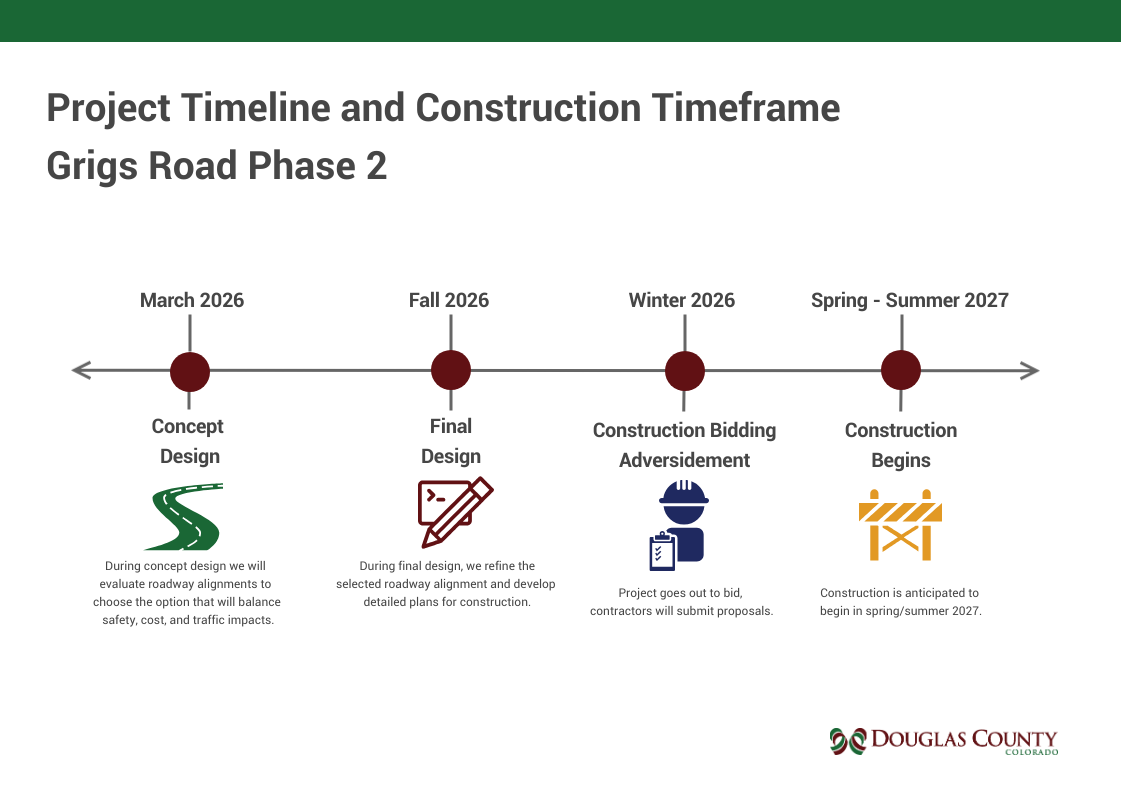
Traffic Impacts
The project is currently in the planning and design phase. When construction begins in 2027, Grigs Road will be fully closed to traffic. The closure will allow for earthwork to modify the roadway alignment and grade, as well as excavation to install stormwater inlets and culverts. A full closure will also allow the contractor to operate on an accelerated schedule and complete the project more efficiently.
Design
Grigs Road Phase 2 is currently in the planning and design phase. Phase 2 design decisions were guided by safety, roadway performance, and connectivity needs. Near the existing trailhead, the team studied multiple alignment alternatives to address the combination of a tight curve and steep grade, ultimately selecting the option that provided the safest longterm solution. Along the straight section of the corridor, the design incorporates chicanes—intentional horizontal curves—to reduce speeding and encourage safer travel speeds. The project also introduces a new multiuse trail connecting the neighborhood to the trailhead along the east side of Grigs Road. This trail provides a connection between the neighborhood to the north and the existing trail constructed by Grigs Road Phase 1. Its alignment required careful consideration of challenging topography and ongoing coordination with plans for the future Wildcat Reserve Park, ensuring the trail can be constructed effectively and serve the community well. The public is encouraged to submit comments on the proposed designs using the project comment form.
Roadway and Trail Exhibit
The roadway and trail alignments selected by the design team are presented below. Click on the map to view high-resolution details.
Public Comment Form
Your feedback is vital to the success of this project. Please share your thoughts below. Public comment will be available throughout the project, but comments regarding the design should be submitted by June 30th 2026 for consideration by the design team.
Douglas County is committed to respecting the privacy of residents and commuters who provide comments, questions, or suggestions regarding the Grigs Road Project. Any information submitted through public comments, surveys, emails, or other forms of communication will be used solely for the purpose of planning, managing, and responding to matters related to this project. Personal information will not be sold, shared, or distributed to third parties for commercial purposes. Douglas County will make reasonable efforts to limit the use of personal information to what is necessary for project-related communication and to safeguard such information in accordance with applicable state laws and county policies.